El Niño: Know your Big Picture
 As city creatures, most people know streets and shortcuts. They know the municipal grid. But they are very unaware of the geologic watershed that runs beneath their feet.
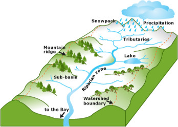
Picture a big cereal bowl. It has rims, sides, and a basin. The land around us is just like this. The mountain peaks around Los Angeles are like the rim of the bowl. The hillsides and slopes around us are like the sides of the bowl. And the gullies and valleys are the basin. This combination of features are what capture and direct water in your area.
Think about the landforms around you in truly large scale. Maybe hop on GoogleEarth and zoom out so that you can see the mountains and creeks all around L.A.
Where is your property located within the bowl?
If you are located on the rim of the bowl, what is beneath you, supporting the building? If you are located on the sides of the bowl, what is uphill from you? If you are located near the basin, how close are you to the very bottom? (Remember that water flows downhill.)
I heard a story of someone who has a property in a well-known canyon in the Santa Monica Mountains. It’s a picturesque property on the creek bottom, with the creek itself channeled to run around his building. He wanted to plant groundcovers to hold back the slopes in anticipation of El Niño.
He has a much bigger problem, that plantings cannot possibly fix. He has a problem with where his small property falls within the huge overall watershed, in the face of potentially catastrophic storms.
Rather than planting, this person would be better advised to buy flood insurance, pack his valuables in a storage unit on higher ground, and have a good evacuation plan in place for his family this winter. When the weather folks are forecasting 1,000 year storms, it’s time to get real and get serious.

